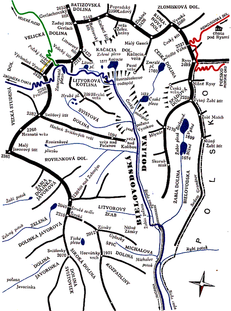
Subvalleys & folds:
Bielovodská dolina
Žabia Bielovodská dolina
Ťažká /Spádová dolina
Kačacia dolina
Litvorová dolina
Svišťová dolina
Rovienky

| Home site | High Tatras - Bielovodská dolina Photogallery of the valley | |
| Subvalleys & folds:
Bielovodská dolina | Bielovodská dolina is one of the largest and most beautiful valleys on N side of Slovakian part of Vysoké Tatry. The lower section of the valley is wooded; the upper section contains several side valleys and these create together in the enclosure of the valley one huge and impressive stone amphitheater. The side valleys: Žabia dolina Bielovodská, Česká dolina with Spádová dolinka, Kačacia dolina with Gerlachovské spády and Litvorová kotlina, Svišťová dolina and Rovienková dolina. On the Polish side of this valley, the side valleys are these: Dolina Rybiego Potoku (dolina Rybieho potoka) and Dolina Roztoki (Roztocká dolina). The prominent peaks above this valley (+ side valleys) are these: Mlynár, Rysy, Vysoká, Ganek, Rumanov štít, Zlobivá, Popradský Ľadový štít, Batizovský štít, Zadný Gerlach, Východná Vysoká, Svišťový štít, Malý Javorový štít, Javorinská Široká and many others. There is a little river running down the valley called Biela voda and at the same time it is the Slovak-Polish border. At the valley mouth is the village Lysá Poľana that is the official border checkpoint. In the middle section of the valley there is the lodge of TANAP (National park administration) located right at the large Bielovodská poľana (mountain meadow). In the upper section of the valley, to the right of Poľana od Vysokou (mountain meadow), on the left bank of Biela Voda, is camp for the climbers (you need a permission from TANAP to use the camp). Getting there: From Javorina (village – or Lysá Poľana – end station of Slovak buses) follow the blue hiking trail to the valley. You shall pass by the lodge and then continue to the camping ground 3 a 1/4 hour. |
 |